
Drag to spin the Mars globe below, use the relief buttons to exaggerate the terrain, and click a spot to sample its height.
The globe's colour and bulge both come from NASA's MOLA laser-altimetry dataset - Relief is stretched for visibility; press Real scale to see how flat Mars actually is next to its own radius.
Distinct from Earth 3D Globe: that page teaches day/night lighting and geography; this page is built from a real downloaded elevation dataset, not a procedural texture.
Mars Terrain Explorer
Spin a Mars globe built from real NASA MOLA elevation data - watch Olympus Mons rise and Hellas Planitia sink as you stretch the relief slider, then click anywhere to read its height.
Which Mars elevation dataset the globe loads
The globe first paints as a plain procedural sphere, then downloads the actual elevation dataset (about 2.6 MB, one time, cached afterward) and rebuilds itself with the real colour ramp and bulge.
The dataset is the NASA MGS MOLA global elevation mosaic from the USGS Astrogeology Planetary Data System - public domain, and served from a dedicated asset host so this page loads fast without bloating this site's own repository. Every figure in the facts panel comes from that mosaic.
Who the Mars globe is built for
Teachers use it to show why "Mars has huge mountains" is true in absolute terms but nearly invisible at planetary scale; students connect the relief slider to the elevation numbers in the facts panel; curious readers click around the globe to see where the tallest and deepest points actually sit.
Mars elevation figures and their sources
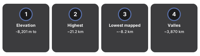
Mapped relief runs from -8,201 m near Hellas Planitia to +21,241 m near Olympus Mons on the areoid datum - a 29.4 km spread across a planet 6,779 km wide.
| Quantity | Value | Source |
|---|---|---|
| Elevation range | -8,201 m to +21,241 m (areoid datum) | NASA MGS MOLA global DEM mosaic |
| Highest mapped region | ~21.2 km (base-to-peak citations vary ~21-25 km by convention) | Near Olympus Mons, the tallest volcano in the solar system |
| Lowest mapped region | ~-8.2 km | Near Hellas Planitia, one of the largest impact basins |
| Valles Marineris | ~3,870 km long; up to ~600 km wide; ~9.3 km deep rim-to-floor at deepest | NASA Science / published canyon summaries |
| Mars mean diameter | 6,779 km (mean radius 3,389.5 km) | NASA planetary fact sheet |
| Source resolution | 463 m/pixel teaching mosaic (2048x1024) | USGS Astrogeology PDS mosaic |
Reading the Mars globe step by step
Open Mars Terrain Explorer, wait for the placeholder sphere to become the real MOLA terrain, then stretch the relief slider and click the globe for an elevation reading at that point. Five moves cover the whole control set.
- Open the page and wait for the plain procedural sphere to be replaced by the real Mars terrain.
- Drag to orbit the globe, keeping the facts panel visible.
- Press Relief + a few times to exaggerate the vertical scale, and watch Olympus Mons rise and Hellas Planitia sink.
- Press Real scale to see how flat Mars actually is at true proportion.
- Click anywhere on the globe to read the real elevation at that point.
Mars Terrain Explorer compared with other Mars elevation tools
Mars Terrain Explorer is the free in-browser way to see real NASA MOLA elevation data on a spinning globe, without installing NASA Mars Trek or desktop GIS software. The heavier options win when the job is mission-grade geospatial analysis rather than fast elevation literacy.
| Option | Real elevation data | Install | Best for |
|---|---|---|---|
| Mars Terrain Explorer | Yes - real NASA MOLA dataset | None (browser) | Fast elevation literacy |
| Earth 3D Globe | Procedural day/night texture, not elevation | None | Geography / lighting |
| NASA Mars Trek | Full mission-grade Mars GIS | Web app (heavier) | Deep geospatial analysis |
| Desktop GIS (QGIS) | Full control, any dataset | Install | Professional mapping |
Everything renders on your device with WebGL through the vendored three.js engine, which loads once (about 0.7 MB) and is then cached alongside the elevation dataset - nothing is uploaded, no account is needed, and no scene data reaches a server.
Mars Terrain Explorer is not a GIS package, shapefile editor, rover-path planner, or live imagery browser - it is a teaching globe from a 2048x1024 MOLA mosaic, not the highest-resolution MOLA products.
For a step-by-step walkthrough, read the Mars Terrain Explorer step-by-step guide. The Space 3D collection also includes Earth 3D Globe and Planet Size Comparison.
Frequently Asked Questions
Is the Mars terrain here real data?
Yes. The globe's colour and bulge come from NASA's MGS MOLA global elevation mosaic (463 m/pixel), public domain via the USGS Astrogeology Planetary Data System - not a procedural texture.
Why does the relief look so exaggerated?
Real Martian relief is under 1% of the planet's radius - almost perfectly smooth at true scale. The relief slider stretches it for visibility; press Real scale to see the true, nearly flat proportion.
What happens when I click the globe?
The facts panel shows the real elevation, in meters, at the point you clicked - sampled directly from the downloaded MOLA dataset.
Where does the elevation data come from?
A dedicated asset host serves the dataset once (about 2.6 MB); your browser caches it afterward so later visits load instantly. Nothing is uploaded from your device.
Is this the same as Earth 3D Globe?
No. Earth 3D Globe teaches day/night lighting and geography with a procedural texture. This page is built from a real downloaded elevation dataset and focuses on Mars relief specifically.
Does any data leave my device?
No uploads and no login. The vendored three.js engine renders on your device; the elevation dataset downloads read-only from a public asset host.