How to Use the Live Wildfire Map - Step by Step
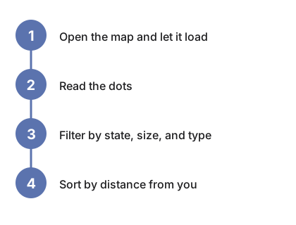
The live wildfire map shows every active US fire the federal NIFC system is reporting, the moment you open it - no steps needed for the default view. The four steps below narrow it to the fires you actually care about: read the dots, filter by state and size, then sort by distance from you.
Step 1 - open the page and let it load
Go to the Live Wildfire Map. The current incident list loads straight into your browser from the federal NIFC WFIGS feed - no account, no app, no API key. Within a moment the status line reports how many incidents match, the map plots them, and the list below ranks them largest-first.
Step 2 - read the dots
Each dot is one incident. Bigger dot = more acres. The color is the containment band: red means little or no containment, orange and yellow mean a partial control line, green means 90 percent contained or better. Grey dots are prescribed burns - planned, controlled fires. Hover any dot to see the fire's name, county, acreage, and containment without leaving the map.
Step 3 - filter by state, size, and type
The state menu narrows both the map and the list to one state, with a live incident count shown next to each state. The size menu hides small fires - show only 100+, 1,000+, or 10,000+ acres. By default the view is wildfires only; tick Include prescribed burns to add the grey RX incidents. Refresh incidents re-pulls the latest data at any time.
Step 4 - sort by distance from you (optional)
Press Sort by distance from me and allow the location prompt. The list re-sorts nearest-first and gains a distance column in kilometers and miles. The permission is one-shot and optional - your location is used in this tab only, never stored, never sent anywhere - and every other feature works without it.
Reading the list
Each row shows the incident name, state, county, acres, percent contained, and how long ago it was discovered. The list caps at the 150 largest matches; if more match, a note under the table says so - narrow the state or size filter to see the rest.
Not sure this is the right tool for your situation? See when to use the wildfire map or compare it against the alternatives.
Why trust these tools
- Ten-plus years of web tooling. The freetoolonline editorial team has shipped browser-based utilities since 2015. The goal has never changed: get you to a working output fast, without an install.
- No install, no sign-up. Open a tool and get a working output in seconds - nothing to download and no account to create. Tools that need heavy processing run it on our service, so even a low-powered machine gets the job done.
- Analytics stops at the page view. We measure which pages get visited, not what you type or upload inside a tool. There is nothing to sign in to and no profile is attached to your input.
- Open-source core components. The processing engines underneath (libheif, libde265, pdf-lib, terser, clean-css, ffmpeg.wasm, and others) are public and audit-able. We link to each one in its tool page's footer.
- Free, with or without ads. All tools are fully functional without sign-up. The Disable Ads button in the header is always available if you need a distraction-free run.